
If you have spent even a single August afternoon in the East Kootenay, you know the scenario. The sun hangs like an orange disc in an ochre sky, the air tastes distinctly of charred lodgepole pine, and the ridge lines above Cranbrook, Kimberley, or the Rocky Mountain Trench are obscured by a thick blanket of smoke.
It seems that almost every summer, our region becomes ground zero for intense wildland fire activity. But why? Is the East Kootenay simply unlucky, or are there fundamental geographical, ecological, and climatic forces at play that make this corner of southeastern British Columbia uniquely susceptible to catastrophic wildfires?
The answer lies in a convergence of environmental factors—a “perfect storm” created by the shape of our valleys, a century of forest management history, extreme microclimates, and shifting global weather patterns.
The Rocky Mountain Trench Effect
To understand wildfire behavior in the East Kootenay, one must first look at the map. The defining geographical feature of our region is the Rocky Mountain Trench, a massive, straight valley extending from the US border hundreds of kilometers north. Flanked by the towering Rocky Mountains to the east and the Purcell Mountains to the west, this valley creates a unique topography that dictates local fire behavior.
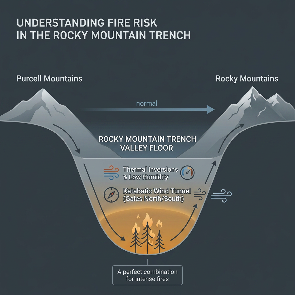
Funneling Winds & Microclimates
Valleys act as natural wind tunnels. When atmospheric pressure differentials build across southeastern BC, the Rocky Mountain Trench accelerates winds, driving dry airflow directly down the valley floor. During summer fire events, these thermal winds fan small spot fires into raging crown fires within a matter of hours, pushing flames rapidly along continuous corridors of timber.
The Rain-Shadow Reality
While the West Kootenay (e.g., Nelson, Castlegar) benefits from higher precipitation levels driven by weather systems coming off the Pacific, the Purcell Range acts as a formidable barrier. By the time air masses cross the Purcells and drop into the East Kootenay valley floor around Cranbrook and Skookumchuck, they have shed most of their moisture. This creates a pronounced rain-shadow effect, leaving the valley floor exceptionally dry throughout July and August.
A Century of Fuel Buildup
Fires are not new to the East Kootenay; historically, the region experienced frequent, low-intensity surface fires sparked by Indigenous cultural burning and natural lightning. These frequent burns cleared out underbrush, thinned small trees, and maintained open, park-like Douglas-fir and ponderosa pine savannas
Historic Fire Suppression
Throughout the 20th century, modern firefighting protocols focused on extinguishing every wildfire as quickly as possible. While this protected infrastructure in the short term, it removed the natural process that periodically cleaned the forest floor. Without regular fire events, our forests grew unnaturally dense, accumulating massive loads of dead wood, fallen needle cast, and crowded understory saplings—the exact fuel required to turn a ground fire into an unmanageable canopy fire.
Mountain Pine Beetle Legacies & Fuel Loading
Adding fuel to the literal fire was the major Mountain Pine Beetle outbreak that impacted millions of hectares of lodgepole pine across interior BC. Decades later, vast stands of dead, gray-phase pine trees remain standing or have fallen across the East Kootenay backcountry. This dry, cured timber provides abundant fuel that burns at higher temperatures, making direct ground suppression extraordinarily dangerous for wildland crews
Protecting Your Property
While we cannot change the geography of the Rocky Mountain Trench or stop dry lightning storms, we can alter how our properties interact with fire. Proactive wildfire mitigation and FireSmart principles significantly increase the probability that a home or commercial building survives an encroaching wildfire.
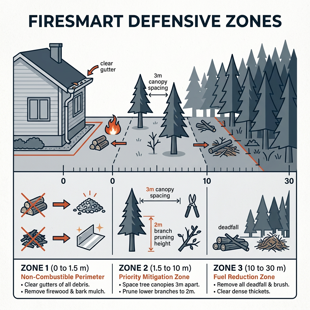
Whether you require proactive tree thinning and fuel reduction around your acreage, localized sprinkler defense installation, or rapid post-fire emergency smoke and soot restoration, taking action before and after smoke fills the valley is critical.
The East Kootenay sits in a deep valley between the Purcell and Rocky mountain ranges. During atmospheric summer inversions, calm air traps smoke near the valley floor. When winds pick up, the valley acts as a funnel, channeling smoke from fires burning in Washington, Montana, the West Kootenay, and local fires directly into communities like Cranbrook and Kimberley.
Wildfires in the East Kootenay are caused by a combination of natural dry lightning strikes during summer storms and human activities such as unextinguished campfires, agricultural burning, and machinery sparks. Dry lightning accounts for the majority of large backcountry burn areas during dry summer months.
Homeowners can adopt FireSmart principles by clearing dead leaves and needles from roofs and gutters, maintaining a 1.5-meter non-combustible zone around structures, spacing coniferous trees at least 3 meters apart within 10 meters of the home, and removing ladder fuels like low-hanging branches.
In the event of fire or smoke damage, contact professional restoration services immediately. Specialized remediation includes thermal fogging, HEPA air scrubbing, and soot cleanup to prevent corrosive smoke residue from permanently settling into wall cavity insulation and structural wood.